
Tuckahoe Neighbors by Record Source
Begin a Tuckahoe neighbors search with the relationship you need to verify. Henrico GIS is strongest for parcel geometry and the lots immediately around an address. The assessment card connects a parcel to owner labels and its deed reference. HOA and civic-directory records can point to a subdivision or an organization contact, but they do not establish membership or residency. Virginia voter information has separate statutory limits and cannot serve as a complete block roster.
| Block record source | What it shows around an address | Access and limits |
|---|---|---|
| Henrico Public GIS Viewer | Tax-parcel polygons, master address points, street centerlines, subdivisions, and nearby map context | Free reference viewer; not a survey or legal boundary determination |
| Real Estate Property Search | Current and Jan. 1 owner labels, situs, mailing ZIP, GPIN/PID, transfer and deed book/page | Free card; owner is not automatically an occupant |
| Henrico HOA lookup | Subdivision and HOA name from an address, with SCC connection | County does not maintain boards, dues, or assessments |
| Henrico Directory of Organizations | Named civic-group contact leads | Contact directory, not a membership list or boundary proof |
| Registrar records | Statutorily limited public voter fields and election geography | Regulated access; protected residences excluded |
A current owner can be an entity, fiduciary, or person with a different mailing address. A directory entry can be historic. A registered agent can be a service contact. Label both the source and the role before drawing a conclusion about neighbors.
Define Tuckahoe Neighbors First
“Neighbor” is not one official field. A touching tax-parcel polygon is a GIS relationship. A home immediately across a street is a postal relationship. A household in the same platted subdivision is an HOA or subdivision relationship. A public voter address is a statutory-record relationship. These categories overlap sometimes, but they are not interchangeable, and a map view should say which one it supports.
- Touching parcel
- A tax-parcel polygon that shares a boundary with the target polygon on the GIS map.
- Across-street parcel
- A nearby parcel separated by the street right-of-way, which should be labeled separately from a touching lot.
- Situs address
- The physical address of the parcel, used to connect map and assessment data.
- Mailing address
- The address used for assessment or tax mail. It may be a post office box, service address, or another residence.
Roads, easements, creeks, and non-parcel features can make a lot look close without making it legally adjacent. The GIS disclaimer matters here: it is a useful reference layer, not a survey. Note: The GIS relationship identifies land parcels, not every person who receives mail or lives nearby.
Map Adjacent Tuckahoe Parcels
Henrico’s GIS hub provides the public viewer and layer services. For a neighbors search, turn on Tax Parcels and Master Address Points, with Street Centerlines available for orientation. Subdivisions or condominiums, historical parcels, voting precincts, zoning, and aerial imagery can add context, but only the parcel and address layers should anchor the adjacency call. The REST service is a useful fallback if the viewer is slow; it supports query, identify, and find. No inspected source establishes a public radius or buffer report, so do not promise one.
- Locate the target street address or GPIN in the Henrico Public GIS Viewer.
- Identify the target polygon and record its GPIN/PID, subdivision, lot, phase or section, and map link.
- Click each polygon that shares a boundary, then identify the immediately across-street parcels separately.
- For every selected lot, carry the GPIN/PID to the property card and record the situs, owner labels, mailing ZIP, deed book/page, transfer date, and map references.
- Use the Circuit Clerk land-record route for recorded ownership and the HOA route for subdivision information. If a polygon lacks a clear address, retain its parcel ID and ask GIS or Assessment rather than guessing.
The process is address to target parcel to adjacent parcel to GPIN/PID to assessment and deed reference. For a longer address-by-address route along a named street, use the Tuckahoe streets directory; the block method stays focused on the immediate surrounding lots.
Read Tuckahoe Neighbor Parcel Fields
The property card is the bridge from a visible map shape to a recorded property record. Typical visible fields include GPIN, PID, state and use codes, tax and magisterial districts, subdivision, acreage, section, block, lot, parcel address, current owner, Jan. 1 owner, mailing address, deed book/page, transfer date and price, assessment values, and Old Map or Pre-1992 Map references. Availability of photos, plats, sketches, and historic-card links varies by parcel.
| Field group | Why it belongs in a block note |
|---|---|
| GPIN/PID | Stable parcel identifiers that join the assessment card to GIS and land-record work. |
| Situs and mailing | Separates the land location from the address receiving tax mail. |
| Owner (Current) and Owner (Jan 1) | Preserves two dated owner labels rather than blending them into one claim. |
| Deed book/page and transfer | Provides a route to the recorded instrument and a dated ownership clue. |
| Subdivision, lot, phase, section | Connects the parcel to the platted community context. |
Owner data on the result does not prove that an owner occupies the situs. The county authorizes public display of non-confidential assessment records but cautions that errors may exist. Confirm an ownership question through the recorded instrument or the custodian when it matters.
Follow Tuckahoe HOA Address Leads
Henrico’s HOA lookup begins with an address, not a roster. Enter the address in the left-pane Find address/place box. The lookup can populate the subdivision and HOA name and outline or highlight the subdivision. Then use the SCC View link to read registered agent, registered office, and principal office information. Those are entity contact fields, not proof that the agent or office is a neighbor or board member.
For covenants or declarations, use the exact HOA name and land-record book/page to request the relevant document from the Circuit Clerk Land Records Room. Henrico expressly says it does not maintain HOA board members, dues, or assessments. This is a useful comparison point: official lookup layers identify a subdivision and entity route, while a private community may control any member-only information itself.
The Henrico HOA lookup instructions show the address-to-subdivision-to-SCC sequence for a Tuckahoe neighbors search.
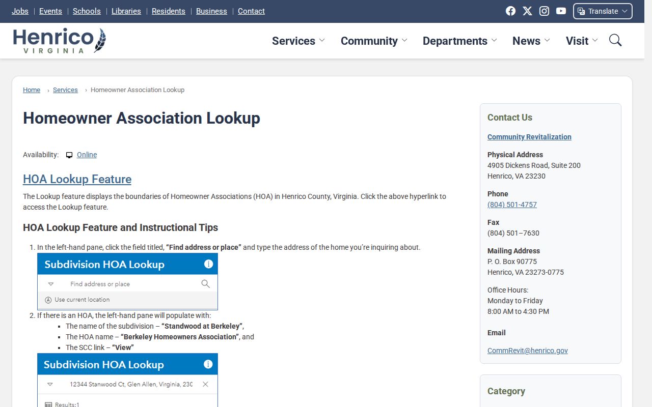
Use the precise entity and recorded-covenant route, rather than assuming the county holds a public community roster.
Tuckahoe Civic Directory Leads
Henrico’s 2023-2024 Directory of Organizations lists several civic associations that can be useful community-contact leads. The document does not establish that every named organization lies wholly inside the Tuckahoe CDP, and its contact information is not a member directory. Confirm the organization’s current scope directly before treating it as relevant to an address or subdivision.
| Listed organization | Directory role | Scope caution |
|---|---|---|
| Gayton-Tuckahoe Civic Association | Civic-association contact lead | Listing does not prove every member or area is within the CDP. |
| Gayton Grove Civic Association | Civic-association contact lead | Confirm current boundaries and contact details directly. |
| Glen Ridge-Rivermont Civic Association | Civic-association contact lead | Do not infer membership or Tuckahoe-wide coverage. |
| Glenbrooke Hills Civic Association | Civic-association contact lead | Listed address is a contact, not a household roster. |
No public Tuckahoe-specific congregation roster, block-watch list, current alumni directory, or chamber membership roll was located in the research. That absence is meaningful. Community contact should begin with the organization itself, not an attempt to reconstruct private membership from public records.
Tuckahoe Voter Records Aren't a Block List
Virginia Code §24.2-444 identifies public voter fields such as name, address, year of birth, gender, and election districts, but excludes Social Security information, full date-of-birth details, and protected residence information. The individual Citizen Portal requires name, date of birth, last four digits of Social Security number, locality, and certification. It cannot be used as a public browse-every-address tool for neighbors.
Registration lists are maintained through the registrar with supplemental schedules and statutory request and use controls. A lawful list may support limited civic-geography work where public address fields are available, but it will not include protected residents and can lag a move. Parcel GIS remains the proper source for adjacent lots; voter data is a separate, limited civic record.
Compare Tuckahoe Neighbor Search Types
Official records document a defined public role and state their access limits. Private commercial neighbor-search categories may combine old addresses, public records, and other data, but their update rules and source dates may be unclear. For a parcel or civic question, the official source and a date-stamped record are the more useful starting point.
| Official local route | Commercial neighbor-search category |
|---|---|
| Shows a parcel, named record role, source date, and custodian limits. | May combine sources without making the record date or role clear. |
| Supports a focused question: adjacency, owner of record, subdivision, or public voter field. | Can suggest a lead but cannot establish parcel adjacency, occupancy, or a complete household. |
| Has a correction or request route through the relevant office. | Requires the private controller’s own privacy or correction process. |
For a historic block, pair each source with a date and role, such as directory/address lead, deed/grantee, assessment/owner display, or GIS/adjacent polygon. This preserves what the source actually showed rather than turning several old references into a current-neighbor claim.
Limits on Tuckahoe Neighbor Lookup
A block search cannot reveal private household members, every mail recipient, utility customers, protected voters, sealed court parties, or DMV address data. The Virginia Address Confidentiality Program can provide a substitute address for qualifying survivors, while a protective-order statute restricts residential, work, and contact information of protected people and families. A current owner may not occupy a lot, an HOA registered agent may be a service address, and an old directory entry may describe a prior occupant.
Henrico’s online property data and GIS layers are reference tools that can change. Date dynamic results and ask the source custodian about an apparent error. Public records can support personal neighborhood curiosity, family history, and safe civic contact, but they do not support surveillance or repeated unwanted contact.
Lawful use. Use a Tuckahoe neighbors search for personal, lawful research and respectful community contact. Do not use parcel, address, or association information to stalk, harass, intimidate, or harm another person.